
Be Visible, Be Predictable, Be Safe » Ride Lawrence
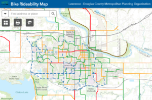
This map is a tool to help you in finding the best route for your skill level. This map varies from the future and existing bicycle facilities map, which is a comprehensive map used as a system planning tool.
Get the Map (PDF) – 2022 Update
Get the Map in Print – find a map at one of our sponsor locations: Anderson Rentals, City of Lawrence City Hall, Cycle Works, Douglas County Human Services Building, Sunflower Outdoor & Bike Shop, Trek Bicycle or Unmistakably Lawrence.
The Bicycle Rideability Map is a product of the City of Lawrence and the Lawrence – Douglas County MPO with input from the Lawrence – Douglas Bicycle Advisory Committee.
 |
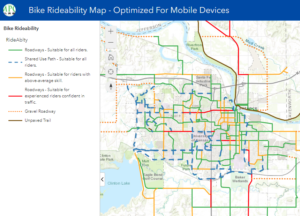 |
| Interactive Map | Interactive Map Optimized for Mobile Devices |
Download the latest Kansas Bicycle Map, from the Kansas Department of Transportation (KDOT)